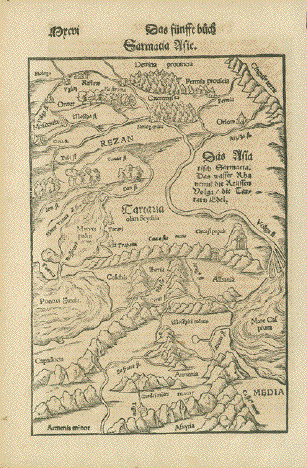
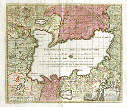
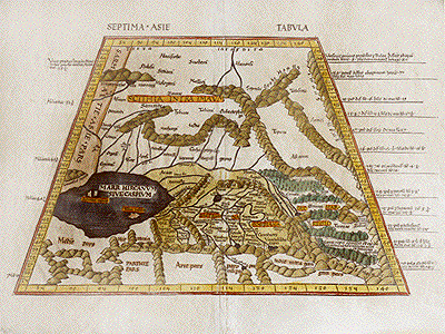
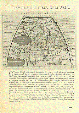
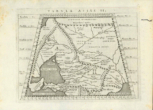
Antique Maps of Central Asia

Kazakhstan, Kirghizstan, Usbekistan, Turkmenistan and Tadzikistan

A selection of historical maps of Central Asia. Each map is illustrated and carefully described. Please contact us if you are looking for a particular map. Maps have normal age toning and a few minor signs of age.
Special faults are mentioned.

Ordering and Payment

Lieferbedingungen

Sale! Discount!

30% Discount on All maps with a CENTRALASIAMAP number on this page!

Take 30% off the listed price. !

Visit us at the following sites:

https://lovelyantiqueprints.com

twitter.com/philographikon2

"Tabula Asiae II."

Copper etching by Girolamo Porro (1520-1604)

After Claudius Ptolemy

Published in "Geographia Universa"

Publisher Giovanni Antonio Magini (1555-1617)

Venice, 1596

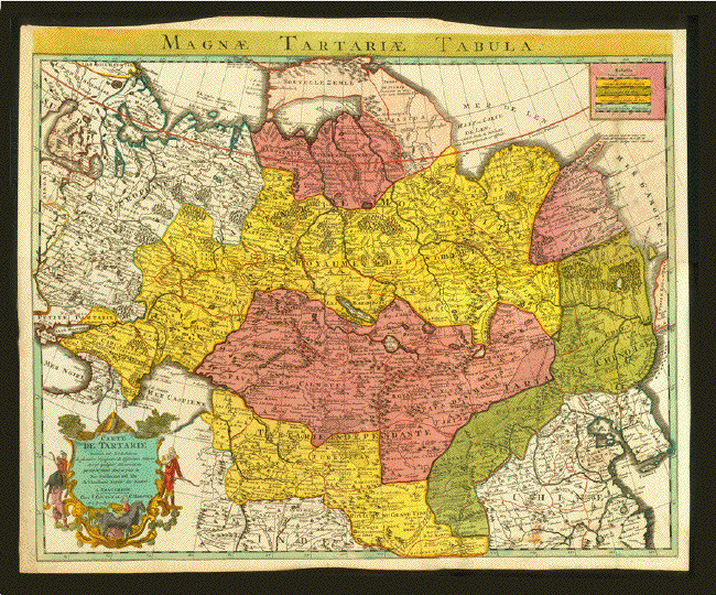
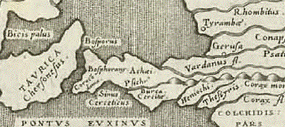
Area shown: Sea of Azov, A bit of northern coast of Black Sea, the northern most part of the Caspian Sea. Part of the Ukraine, Southern part of Russia, as seen by Ptolemy.

There is a worm hole upper right margin not touching map.. Reverse side has text in Latin.

13,3 x 17 cm  (ca. 5.2 x 6.7")

$ 95.00

Order Nr. RUSSIA253877


Magnae Tartariae Tabula

Magnae Tartariae Tabula

Magnae Tartariae Tabula

Magnae Tartariae Tabula

"Magnae Tartariae Tabula"

"Carte de Tartarie dressée sur les Relations de plusieurs voyageurs des différents Nations et sur quelques Obeservations qui ont etes faites dans ce pais laÉ"

Copper etching in bright unique original hand coloring.

Etched by Guillaume del Isle (1675-1726)

Published by Covens & Mortier

Amsterdam, 1742

The upper image was scanned with a black background and show that the upper margin is uneven.

49 x 61 cm ( ca. 19.3 x 24")

Order Nr. CENTRALASIA249834SOLD


"Tartaria sive Magni Chami Imperium" Tartary or the Empire of the Great Khan. Copper etching from the world atlas published by G. Blaeu. Amsterdam, ca. 1640, Extremely fine original hand coloring, athe few city marks hightened with gold.

Shows large parts of Central and Northern Asia from the Caspian Sea and the Ural mountains to the Pacific and the Chinese Wall. Comprises Turkmenistan, Kazakhstan, Mongolia, Manchuria, Siberia, parts of Iran and parts of China.

A very beautiful map. Ample margins. General age toning. Map and the two decorative cartouches are absolutely beautifully hand colored. A few minor traces of age and use. Very nice condition.

38 x 49.5 cm (15 x 19.5").

Order Nr. CENTRALASIAMAP 2904 SOLD


"Sarmatia Asie"

Geographical area between Moscow (upper left) - runs of the Rivers Volga to its delta in the Caspian Sea, and Don - Armenia - the Black Sea. Sources of Euphrat and Tigris. Center of map is Georgia, Caucasus

Very early map of this geographical area where South-East-Europe meets Asia. This map is not repeated in later editions of "Cosmographia"

Woodcut. Published in "Cosmographia" by Sebastian Muenster (1488-1553)

Published in Basel, 1553

Age toned. Otherwise very good condition. Verso: Unrelated text print.

23,7 x 16,2 cm ca. 9.3 x 6.4")

$ 280.00

Order Nr. CAUCASUSMAP253256


"Russisch-Centralasien und Turkestan"

Detailed map showing the borders of 1895. Published in leipzig.
Light age toning. Vertical centerfold..

Image:22 x 26 cm ( 8.6 x 10.2 ")

Order Nr. CENTRALASIAMAP244434 SOLD


Persici sive Sophorum Regni Typus

"Persici sive Sophorum Regni Typus"

Copper etching. Renaissance map from the first world atlas "Theatrum Orbis Terrarum" by Abraham Ortelius, Antwerp, 1570.

Very attractive hand coloring.

This is a map from the very first edition. Reverse text is in Latin. Page number is 85. With watermark.

Map shows Persian Empire which included Afghanistan and Central Asia. The Persian Gulf is nicely shoown with
Bahrain, Kuwait, Bagdad and Babylon. The Caspian Sea is to the north. Elegant Renaissance cartouche.

Condition is Very Good.

34.5 x 49 cm ( 13.6 x 19.3 ")

$ 820.00

Order Nr. MIDDLEEAST234628


"Nord-&Mittel-Asien Übersicht des Russischen Reiches"

North and Central Asia - Russian Empire"

Steel engraving after the drawing by August Heinrich Petermann (1822-1878)

Published in Gotha, dated 1874

Light original borderline and area coloring

A few foxing spots in map and margins.

33,4 x 40 cm (ca. 13.1 x 15.7")

$ 90.00

Order Nr. ASIA248041


"Turkestan 1845 "

Near the center of this map is Lake Aral with Khiva to the south. In the upper right is the region
of Kalmouks. In the lower left is Teheran.

Steel engraving map ca 1845. Vertical folds to fit book size.

17.2 x 22.5 cm ( 6.7 x 8.8 ")

Order Nr. CENTRALASIA239923SOLD


"Carte De L Expedition D Alexandre Pour lÔintelligence de lÔHistoire de la Grece" Copper engraving by Jean Baptiste Bourguignon D'Anville ca 1750.

This interesting map traces the route by dotted lines of Alexander the Great on his Asian expedition. In the lower right corner is the mouth of the Indus River and the end of the marked expedition lines. The marked lines are sometimews light on an otherwise strongly printed map.

Map has folds to fit original book size. In the lower left margin is a small part missing and a small repaired tear.

24.5 x 42.8 cm ( 9.6 x 16.8 ")

$ 220.00

Order Nr. MIDDLEEASTMAP18842


ãDescrittione Dell'Imperio della MOSCOVIA".

Map includes Latvia, Livonia, Lithuania, the Ukraine,

Northern Part of the Black Sea and the Caspian Sea,

Siberia, Georgia, Azerbaijan, Kazakhstan

Type of print: Copper etching

Artist: Girolamo Porro

Published in: ãGeografia cioe Descrittione Universale della Terra"

Publisher: Gio. Battista & Giorgio Galignani Fratelli

Edition: Italian edition

Editor: Giovanni Antonio Magini (1555-1617)

Text: Italian. Complete on front and reverse side

Published in: Venice. Date: 1598

Measurements:

Map size: Ca. 12,5 x 17 cm (ca. 4.9 x 6.7")

Page size: Ca. 28,5 x 19 cm (ca. 11.2 x 7.5")

Condition: Near perfect. Very minor traces of age.

Price: $ 280.00

Order Nr. RUSSIAMAP238495


The Caspian Sea. "Nova et accuratissima Maris Caspii hactenus maximam partem nobis non satis cogniti ac Regionum adjacentium Delineat jussu Invictissimi Principis Petri Alexii Filii Magni Russorum Imper. ..." Copper etching. Published by Matthaeus Seutter. Augsburg, ca. 1740/50. Very fine original hand coloring.

This north-oriented map of the Caspian Sea shows adjacent lands of Russia, Turkmenstan,Kazakhstan, Iran, Azerbaijan. Very nicely shown: The Wolga delta

Except for a frayed extremity of the margins in very good condition.

48.5 x 57.3 cm (19 x 22.5")

$ 850.00

CENTRALASIAMAP 2902


"Das Caspische Meer wie solches auf Ihre Gros-Czaar durch einen See-Capitain abgezeichnet ..." (Caspian Sea)

"Das Land Kamtzadalie sonst Jedso..." (Kamchatka)

Copper etching in original borderline hand coloring. Published by Johann Baptist Homann. Nuremberg, 1723

This two-tier map shows in great detail on the left the Caspian Sea and on the right Kamchatka peninsula with the kurile Islands. Map is divided by central part with the title cartouche allegories looked upon by the eye of God.

Flawless.

48.5 x 57.5 cm (19 x 22.6")

$ 600.00

Order Nr.CENTRALASIAMAP235371


"Septima Asie Tabula". Woodcut by Philesius and Waldseemueller. Strasbourg 1513. Based on Claudio Ptolemy! Hand coloring, probably mid 20th century.

Map of the Caspian Sea and the bordering lands: ãScithia intra Imaum", ãBactriana" ãSachar Regio". Map shows northern Iran, southern Russia, Kazakhstan, Turkmenistan, eastern Azerbaijan, Afghanistan, Tajikistan, Uzbekistan, and portions of Pakistan and India.

Wide margins. Small tears and a little fraying along margin edges. Top margin has two little pieces missing. General age toning. A few thin spots along center fold not detectible from the front. Minor traces of age and use. But actually in very nice condition.

Page size: 44 x 60 cm (17.3 x 23.6")

$ 2500.00

Order Nr. CENTRALASIAMAP 2905


"Carte de la Georgie et des pays situes entra la Mer Noire et la Mer Caspienne"

Copper etching by Joseph-Nicolas de L'Isle. Publisher Santini. Venice, 1775

This map was first drawn and translated from the Georgian language into French in St. Petersburg in the year.1738. It was first published in the atlas by de L'Isle in Paris in 1766. This here is the rare Italian edition

The map extends from the eastern shores of the Black Sea to the western shores of the Caspian Sea (Baku), including Azerbaijan, and Armenia as well as parts of Turkey. including Lake Van.

Flawless

48 x 65 cm (18.9 x 25.5")

Order Nr.CAUCASIAMAP235341 SOLD


"Carte de L'Empire de Perse" (Iran)

Copper etching with original borderline hand coloring.. By Jean Baptiste Burgiunnon D'Anville (1697 - 1782). Italian edition by Santini. Venice, 1779

Map shows southeast corner of Black Sea, Georgia, Armenia, parts of Turkey, but mainly Persia (Iran). Western Afghanistan and western Pakistan (to Kashmir) is also shown as well as parts of Kazakhstan, Uzbekistan and all of Turkmekistan

Flawless

47.5 x 60 cm (18.7 x 23.6")

$ 750.00

Order Nr.MIDDLEEASTMAP235342


"Royaumes De Perse Herat & Kaboul Confed. des Beloutchis Principaute de Sindhy, Conf. des Seikhs on Roy de Lahore et la partie la plus peuplee Du Turkestan Independ." Steel engraving by V. Levasseur. 1852. In the center is some original outline coloring. The map text is in French.

Detailed historical map of the region.Herat is almost in the center of the map. In the upper left is a small part of the Black Sea. In the upper right is part of Turkestan and Buchara. In the lower right is part of Hindustan. The border has various decorative elements.

22.8 x 30.5 cm ( 9 x 12")

Map is in very good condition.

$ 145.00

Order Nr. MIDDLEEASTMAP18841


"Tavola Sesta Dell'Asia" (Sixth Ptolemy map of Asia)

Arabia Felice - Felix Arabia

Copper etching after Claudius Ptolemaeus published in ãGeografia cioe Descrittione Universale della Terra" Gio. Battista & Giorgio Galignani Fratelli. Venice, 1598

First edition in Italian prepared by Giovanni Antonio Magini (1555-1617)

Map shows Arabia and the coastlines of Iran and Africa opposite.


Reverse side: "Tavola Settima Dell'Asia" ( the seventh Ptolemy map of Asia)

The Old Persia and neighboring Turkmenistan, Afghanistan and Pakistan

Light general age toning. Some very minor oxing. and very minor traces of age and use.

Maps sizes on either side:

Sheet: 28.5 x 19 cm (11.2 x 7.5")

Map: 12.4 x 17 (4.9 x 6.7")

$ 350.00

Order Nr.MIDDLEEASTMAP234647


"Tartariae Magni Mogolis Imperii, Iaponiae et Chinae Nova Descriptio" Tartaria, Japan and China Copper etching. Published by Frederic de Wit. Very fine original hand coloring. Amsterdam, 1686

This very decorative map shows the Asian land mass between the Northern Circle and the Tropic of Cancer from The Caspean Sea and the Ural Mountains to Japan, Korea ,China and Taiwan. It includes all of Central Asia, large parts of Iran, Pakistan, Afghanistan, Turkmenistan, Kazakhstan, Northern India, Tibet, Mongolia, Siberia. Forests, mountains, deserts have been drawn in. A very attractive map

Pleasant general age toning. Wide margins, extra fine original hand coloring

43.5 x 55 cm (17.1 x 21.7").

$ 800.00

Order Nr. CENTRALASIAMAP 2903


"Zentralasien und Vorderindien"

Very detailed map dated 1898. Map shows the main road systems of the time as well as the existing railway system.
The light green areas are British territory and the beige areas are Russian territory. Some shipping routes are shown.

Very decorative and informative map for someone interested in this part of the world.

Map is in very good condtion. Horizontal centerfold. Very light age toning in margins.

Map image: 47 x 36.5 cm ( 18.5 x 14.3 ")

Nr. CENTRALASIA242811 SOLD


"Nova Maris Caspii et Regionis Usbeck cum Provincija adjacentibus vera Delineatio". Copper engraving by A. Maas for the Homann Heirs. Dated 1735.Original hand coloring.

Interesting map of the region of West Central Asia and Eastern Cucasus region. In the lower right is Kabul and Parwan. In the lower right is Bagdad and the ruins of Babylon.

Map is in good conditon. Vertical centerfold.

49 x 58 cm ( 19.2 x 22.8 ")

Order Nr. CENTRALASIAMAP2901SOLD


Antique Prints of Central Asia

Maps of the World

PRINTS OF THE ENTIRE WORLD: Antique town and city views.

ANIMALS

ARCHITECTURAL PRINTS

ARCHEOLOGY PRINTS

ASTROLOGY, OCCULT, WITCHES

ASTRONOMY

BANKS and FINANCE

BOOKS

BOTANICAL PRINTS

INTERIOR DECORATION

MEDICINE AND MEDICAL PROFESSIONS

Ordering and Payment

E-mail

Terms of Sale - Lieferbedingungen

Return to Home Page

Impressum

Datenschutz

© Rainer Rauhut